How Do Self-Driving Cars See the Road? Inside the Tech

Autonomous vehicles are no longer science fiction; they are a daily presence on the streets where you walk, cycle, and commute. Trusting a machine with your personal safety demands knowing exactly how it detects the chaotic environment around it.
Human drivers rely on a pair of eyes and quick instinct to avoid sudden obstacles or read a faded speed limit sign. A self-driving car must replace human sight with complex computational perception.
The ultimate challenge lies in translating unpredictable physical surroundings into precise digital data fast enough to prevent a collision. Unpacking the mechanics behind this transition reveals exactly how an arrangement of sensors, processors, and artificial intelligence turns an unguided machine into an exceptionally aware driver.
Key Takeaways
- Autonomous cars rely on a fusion of optical cameras, LiDAR lasers, radar, and ultrasonic sensors to build a complete three-dimensional model of their surroundings.
- Relying on multiple sensor types provides overlapping coverage, ensuring the vehicle continues operating safely if blinding light or heavy rain disables a specific camera.
- Deep learning algorithms analyze the incoming sensor data to categorize objects like pedestrians and cyclists, allowing the computer to predict their upcoming movements.
- Vehicles confirm their exact geographical location by comparing real-time LiDAR scans of the street against pre-loaded, centimeter-accurate 3D maps.
- Engineers tackle bad weather and dirty lenses by shifting reliance to radar in low visibility and installing automated sprayers and heaters to clear physical obstructions.
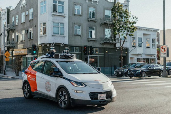
The Sensor Hardware Suite
A self-driving vehicle depends on an array of highly specialized hardware to perceive its surroundings. Rather than relying on a single source of input, the system utilizes multiple sensor types distributed across the vehicle exterior.
Each sensor gathers specific data, compensating for the limitations of the others to create a comprehensive view of the environment.
High-Resolution Cameras for Visual Detail
Optical cameras act as the eyes of the vehicle, capturing color, texture, and visual context. They are essential for reading traffic lights, identifying street signs, and recognizing the brake lights of vehicles ahead.
However, camera-only systems face significant limitations. Poor lighting, heavy shadows, or direct glare from the sun can easily blind optical lenses, making them unreliable as the sole source of visual data.
LiDAR Technology for Three-Dimensional Depth
To establish precise depth and dimension, self-driving cars utilize Light Detection and Ranging, commonly known as LiDAR. This technology fires millions of laser pulses per second, measuring how long it takes for the light to bounce back from surrounding surfaces.
The result is a highly accurate, three-dimensional point cloud of the environment. LiDAR provides exceptional precision in distance measurement and captures the exact shape of objects, allowing the vehicle to distinguish between a flat billboard and a volumetric pedestrian.
Radar Sensors for Distance and Velocity
Radar sensors use radio waves to track target velocity and range. By bouncing radio waves off moving metallic objects, radar instantly calculates how fast a leading vehicle is traveling or how rapidly an oncoming truck is approaching.
Furthermore, radar offers strong performance resilience in poor conditions. Unlike optical cameras and lasers, radio waves easily penetrate dust, fog, heavy rain, and complete darkness.
Ultrasonic Sensors for Close-Range Proximity
For immediate, close-range proximity detection, ultrasonic sensors rely on sound-wave technology. These sensors emit high-frequency sound pulses to measure nearby obstacles, primarily assisting with low-speed maneuvers and parking.
They excel at detecting immediate blind spots, parallel vehicles, and low physical curbs that might sit beneath the field of view of the primary cameras and LiDAR.
Sensor Fusion and Data Integration

Gathering information is only the first step in the perception process. The vehicle must immediately organize the massive influx of data coming from cameras, LiDAR, radar, and ultrasonic units.
This requires a robust internal network capable of merging disparate signals into a single, cohesive picture.
The Concept of Sensor Redundancy
Multiple sensor types are necessary to offset individual hardware weaknesses. If blinding sunlight incapacitates a front-facing camera, radar continues to track the speed of the car ahead.
If dense fog limits LiDAR ranges, radar still penetrates the mist. This overlapping coverage creates essential sensor redundancy.
Maintaining redundant systems drastically improves safety implications, ensuring that the failure or blinding of one sensor does not leave the vehicle entirely blind.
Central Computer Systems
The architecture of high-performance onboard computers processes this immense volume of data. These systems act as the brain of the vehicle, built to handle calculations at lightning speeds.
The raw data aggregation requires massive computational power because the vehicle must interpret millions of data points every second. Without this immense speed, the car would react too slowly to sudden changes in traffic.
Real-Time Environmental Reconstruction
Through a process known as sensor fusion, different data feeds combine to create a unified 3D model of the vehicle’s surroundings. The computer simultaneously evaluates input from all sources and constructs a live, accurate simulation of the street.
During this process, the software is responsible for the elimination of discrepancies between conflicting sensor readings. If the camera identifies a shadow but the LiDAR confirms empty space, the fusion system weighs the data and determines the road is clear.
AI-Driven Perception and Object Classification

With a complete 3D model generated by the hardware suite, the vehicle must actually identify what the objects in that model represent. Artificial intelligence takes over the task of analyzing the data, applying complex algorithms to classify everything from human beings to painted lines on the asphalt.
Neural Networks for Image Recognition
The application of deep learning allows the vehicle to recognize visual patterns with high accuracy. The vehicle relies on neural networks, complex algorithms modeled loosely on the human brain, to process incoming images.
Engineers train these vision models on extensive visual datasets containing millions of hours of driving footage. Through repeated exposure to countless images of vehicles, trees, and roads, the AI learns to quickly identify physical objects in its path.
Distinction and Categorization of Road Obstacles
It is not enough to simply know an object is present. The software must categorize it.
The AI continuously processes the classification of pedestrians, cyclists, non-moving vehicles, and static debris. Recognizing the specific type of obstacle allows the system to run path and behavioral predictions for active road users.
The vehicle anticipates that a bicycle might swerve to avoid a pothole, whereas a parked truck will remain stationary.
Interpretation of Traffic Signs and Lane Indicators
The vehicle also performs visual decoding of speed limits, turn restrictions, and temporary hazard signs. As it drives, the system scans the roadside to adjust its speed or change lanes according to local laws.
This also involves the analysis of lane boundaries, crosswalks, and intersection geometry, ensuring the car understands where it is legally allowed to position itself before making a turn or stopping for pedestrians.
Vehicle Localization and Global Navigation

Identifying the immediate environment is critical, but a self-driving car also needs absolute certainty about its geographical location. To plan a safe route and anticipate upcoming intersections, the vehicle cross-references its real-time sensor data against an array of mapping and satellite technologies.
High-Definition Maps for Spatial Context
Standard consumer maps are insufficient for autonomous driving. Self-driving cars rely on centimeter-accurate 3D maps that provide an exact replica of the environment.
These high-definition maps provide the vehicle with prior knowledge of lane configurations, physical curb heights, and fixed signs. Before the car even turns a corner, it already knows the exact width of the street and the location of upcoming stoplights.
Satellite Navigation Systems and Inertial Measurement Units
Global navigation satellites play an important role in high-level route planning, guiding the general path from origin to destination. However, standard GPS signals can fluctuate.
To maintain precise orientation, the car uses inertial measurement units. These internal devices track vehicle orientation and acceleration, measuring exactly how far and fast the car has moved even if the satellite connection temporarily drops.
Comparison of Prior Map Data with Live Sensor Feeds
The car verifies its exact coordinate position by comparing live sensor data with static map baselines. As the LiDAR scans a nearby traffic light or building, the computer checks this physical reading against its high-definition map.
This constant matching process is the method used to maintain path accuracy when satellite signals are blocked or degraded, such as when driving through a deep tunnel or an urban canyon of tall buildings.
Environmental Challenges and Technical Solutions
Even the most advanced autonomous systems encounter chaotic situations that disrupt standard operations. Bad weather, poorly maintained roads, and physical obstructions present constant hurdles, forcing engineers to develop creative workarounds to keep self-driving cars operational and safe.
Low-Visibility and Adverse Weather Scenarios
Heavy rain, snow, and dense fog severely impact laser reflection and optical focus. Water droplets can scatter a LiDAR laser, while thick mist easily blinds an optical camera.
In these scenarios, the system shifts its primary reliance to radar and heat signatures. Because radar waves pass directly through snow and rain without scattering, the vehicle can still track the speed and distance of other cars when visual sensors fail.
Faded Lane Lines and Unmarked Roadways
Cities frequently have poorly maintained streets with faded or entirely missing paint. System algorithms must infer path boundaries without clear paint lines to follow.
The AI achieves this by observing the use of physical boundaries, including curbs, grass lines, and guardrails, for path determination. By analyzing the trajectory of other vehicles and the physical edges of the asphalt, the car calculates a safe, logical lane to follow.
Sensor Contamination and Physical Obstruction
The external location of cameras and lasers exposes them to the elements. There is a constant threat of dirt, mud, and water droplets settling on external lenses and sensors, entirely blocking their view.
Manufacturers implement mechanical solutions to clear these physical obstructions automatically. Vehicles are equipped with integrated lens washers that spray cleaning fluid, protective shields that repel debris, and thermal heaters that melt ice and snow away from the sensor housings.
Conclusion
The successful operation of an autonomous vehicle depends entirely on the seamless integration of external hardware and internal software. While cameras and lasers gather massive amounts of physical data, high-speed processors and advanced artificial intelligence must instantly interpret that information to control the vehicle.
This multi-sensor redundancy creates a highly reliable system that is far less susceptible to blind spots, distractions, or bad weather than a typical human driver. Achieving full vehicle autonomy demands extreme visual precision at every moment.
By constantly scanning, categorizing, and reacting to the unpredictable environment, self-driving cars transform raw data into a safe and highly capable transit solution.
Frequently Asked Questions
How do self-driving cars see at night?
Autonomous vehicles use radar and LiDAR to operate safely in complete darkness. While standard optical cameras struggle without streetlights, laser pulses and radio waves do not require external illumination to detect objects. This allows the internal computer to maintain a perfect 3D view of the road ahead.
What happens if a sensor gets dirty or covered in snow?
Self-driving cars feature built-in mechanical solutions to automatically clear obstructed lenses. Manufacturers install integrated fluid washers, thermal heaters, and protective air shields directly over the sensors. If a camera remains blocked, the vehicle relies on overlapping data from unaffected radar and laser units to safely pull over.
Can autonomous cars drive in heavy rain or fog?
These vehicles switch their primary focus to radar when heavy precipitation blinds optical cameras and scatters laser signals. Radar relies on radio waves that easily pass through dense fog, thick snow, and torrential downpours. This ensures the computer can still calculate the speed and distance of surrounding traffic.
How does the car know where the lane is if the lines are faded?
The internal artificial intelligence infers the correct driving path by analyzing physical road boundaries. The system looks for concrete curbs, grass edges, and guardrails to determine the edge of the street. It also tracks the trajectory of nearby cars to maintain a safe position on unmarked asphalt.
Why do self-driving cars need high-definition maps?
Centimeter-accurate 3D maps give the vehicle essential prior knowledge about lane widths, physical curb heights, and fixed traffic signs. Standard consumer mapping applications lack the extreme precision required for safe automated driving. These detailed baselines allow the car to cross-reference its live sensor feeds and verify its exact location.


